


Severe convective storms (SCSs) occur during all seasons in the United States. According to Aon, [1] severe convective storms have accounted for 70% of global insurance losses in recent years, and there continues to be a rise in such losses, largely due to growing exposure. In the US state of Texas alone, between January 1, 2012, and January 1, 2024, large hail originating from severe convective storms occurred an average of 197 days per year—more than in any other state. There was also an average of 49 days per year of at least one reported tornado, where Texas also stands as the leader, with 176 days on average of reported thunderstorm wind damage.
While Texas holds the record for average number of annual severe convective storms, it is also the largest state in the continental United States (excluding Alaska), and severe weather does not stop at state and national borders.


Figure 1 – A convective storm (Source: https://blog.response.restoration.noaa.gov/lightning-safety-awareness-threat-lives-and-infrastructure).
What Is a Severe Convective Storm as Defined by Meteorologists?
In the United States, the common term used by meteorologists is “severe thunderstorm.” A severe thunderstorm is defined by the National Weather Service [2] as a storm which produces at least one of the following events:
- Hail that is 1.0-inch (~25 mm) or greater in diameter.
- Winds (including gusts) of 50 knots (~58 MPH) or greater, or associated damage characteristic of such wind.
- A tornado.
This definition differs from other nations, such as Canada, where Environment Canada defines a severe thunderstorm as a storm which produces at least one of the following events [3]:
- Hail of 2.0 cm (20 mm / ~ 0.79 inches) or greater in diameter.
- Wind gusts of 90 km/h (56 MPH) or greater or associated structural wind damage.
- Heavy rainfall based on set/defined criteria as outlined by Environment Canada.
Severe convective storms can occur in nearly all geographies but are most typical in mid-latitude regions around the globe. The premise is simple: access to warm, low-level moisture; cold temperatures aloft resulting in atmospheric instability; and a triggering mechanism allowing for the warm, moist air at the low levels of the atmosphere to be lifted aloft and condensate into a large storm cloud by the process of atmospheric convection. If the resultant cloud begins to rain, the event is known as a rain shower (or convective shower). If the storm produces lightning, the storm is considered a thunderstorm.
It is possible for convective showers—absent of lightning—to result in severe-caliber winds and even tornadoes, though most severe convective storms also contain lightning and, hence, are known in the United States as “severe thunderstorms.” It would be physically difficult for severe-caliber hail to occur without the presence of lightning within a storm, as the mechanisms which promote lightning generation within a storm are generally necessary to result in hail growth. Notably, there is no minimum rainfall accumulation criteria for a convective storm, meaning that a severe thunderstorm may occur without any rainfall. One such event is known as “virga.”

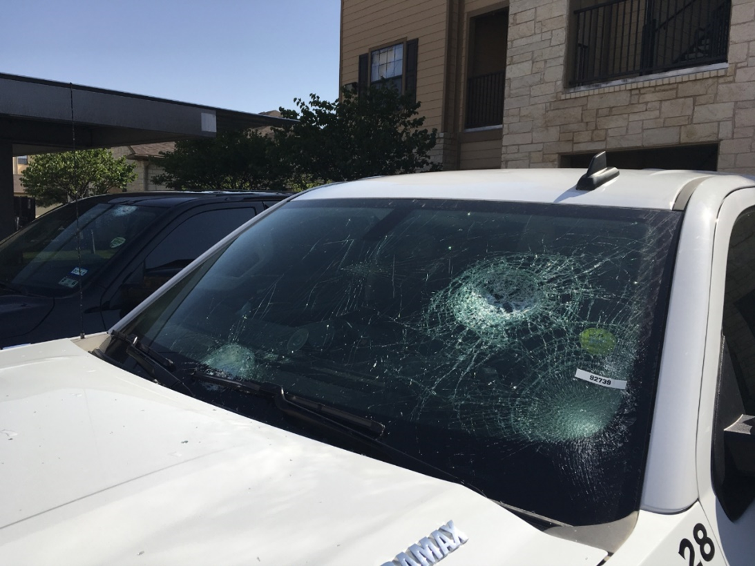
Figure 2 – Hail damage (Source: NOAA Damage Assessment Toolkit (Source: https://services.dat.noaa.gov/arcgis/rest/services/nws_damageassessmenttoolkit/DamageViewer/FeatureServer/0/1384003/attachments/837675).
Modes of Convective Storms
There are three different modes of convective storms: ordinary, multi-cell, and supercell storms. A fourth mode is known as a squall line, though many argue this is a type of multi-cell event.
Ordinary convective storms are storms which have no particular organization and generally “pop-up,” often during the heat of the day. They do not usually last long before dissipating.
Multi-cell storms are events where multiple individual storm cells organize into a cluster, but generally behave somewhat independently. Older cells can dissipate, and newer cells can form, all within the same event.
Squall lines are an organized line of storms which often form along or ahead of frontal boundaries and/or atmospheric troughs. They are generally fast-moving with short dwell times but may travel long distances. Derechos, for example, are a special type of squall line.
Supercell storms are generally long-lived, organized, single-cell storms that feed off strong updrafts that are tilted vertically and rotate. When this rotation of the storm is detected by radar, it is known as a “mesocyclone,” though this radar-observed feature is purely descriptive of the rotation of the storm, not its actual effects or impact on the ground. Tornadoes are most common in supercell storms, though not every supercell storm results in a tornado.

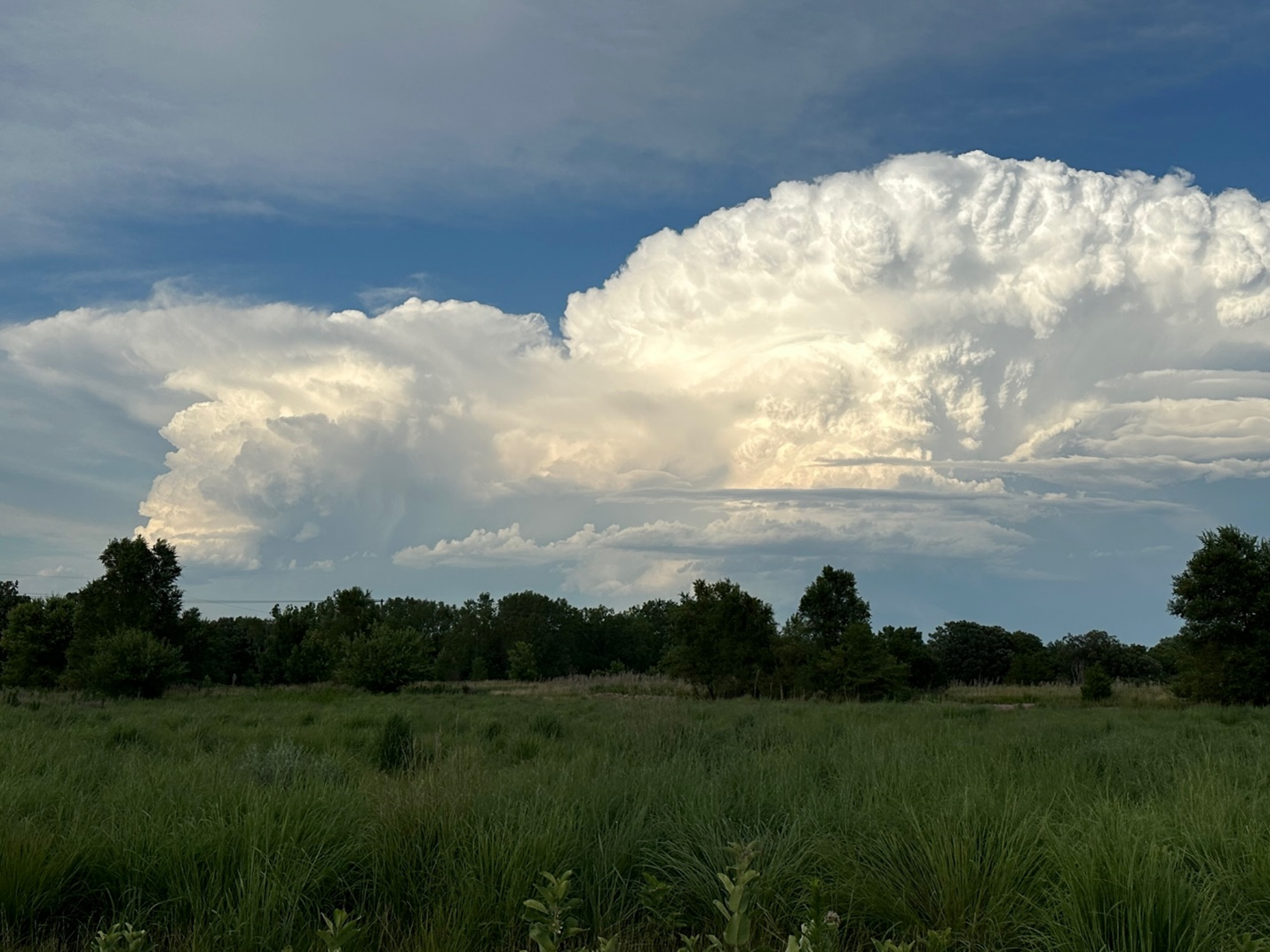
Figure 3 – Cumulonimbus clouds associated with supercell thunderstorms (Source: https://www.weather.gov/fsd/20230713_hail_sesdswmnnwia).
Severe Convective Winds
The most common severe convective winds are a result of downdraft activity. These winds occur in several ways, the most common two being downbursts (microbursts/macrobursts), which are caused by plummeting air from the core of a storm cell, and bow echoes caused by sinking high winds from the mid-levels of the troposphere responsible for propelling a storm line. More on these types of winds can be found in our related article here.
Severe-caliber winds that originate from convective storms can travel tens of miles outside of a storm and have been known to cause structural damage, injury, and even death. One way this can occur is from a gust front (also known as an outflow boundary). This wind event is caused by storm downdraft(s) and it manifests in a way that is similar to ripples forming in a pond when a rock is tossed in. In the analogy of the rock in the pond, the initial impact “splash” point represents the area of the storm’s downdraft, while the ripples represent the outflow boundary, which extends outward far from the impact point of the original “splash.” In some cases, this wind can maintain severity for many miles outside of storm activity and be accompanied by no rainfall at all.

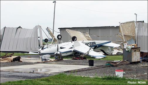
Figure 4 – Wind damage (Source: https://www.weather.gov/safety/wind).
Severe convective storm winds can also be even more complex, such as when a storm event is oriented along a fast-moving cold front. This results in a combination (or hybrid) of both convective winds and non-convective, pressure-driven winds. In these cases, it can be somewhat tough to differentiate which wind speeds would have occurred absent of the convective storm and simply just associated with the fast-moving front. Regardless, in the United States, it is generally practiced in operational meteorology that if winds of 50 knots (~58 MPH) or greater occur in the presence of a thunderstorm, the event is considered a severe convective storm, regardless of the amount of contribution by non-convective processes.
One caveat to this are winds originating from tropical cyclones (hurricanes, tropical storms), which are often hybrid winds with a large portion being pressure-driven by the deep low-pressure found within the eye of the storm. However, convective downdraft wind gusts have also been documented within a tropical cyclone’s wind field, though these winds are generally considered by meteorologists to be part of the overarching tropical cyclone event itself. In these events, criteria for a severe thunderstorm may technically be met (if lightning is also occurring), though the parent storm is not usually considered a severe thunderstorm. This differs from tornadoes (discussed later) which can occur in tropical cyclones.
According to National Weather Service data stored in the Iowa Environmental Mesonet (IEM) database, the top five states for reported thunderstorm wind gusts (by number of days between January 1, 2012, and January 1, 2024) are:
- Texas (12-year average; 157 days per year)
- Kansas (12-year average; 119 days per year)
- Nebraska (12-year average; 81 days per year)
- Oklahoma (12-year average; 73 days per year)
- South Dakota (12-year average; 72 days per year)
However, when identifying reported thunderstorm wind damage—which may sometimes be a result of sub-severe winds—the top five states are:
- Texas (12-year average; 176 days per year)
- Georgia (12-year average; 155 days per year)
- North Carolina (12-year average; 151 days per year)
- Florida (12-year average; 138 days per year)
- Virginia (12-year average; 118 days per year)
Severe Hail
By definition, hail is “precipitation in the form of balls or irregular lumps of ice, always produced by convective clouds.” [4] Hail generally grows within regions of a storm in which temperatures are between about -10°C to -30°C. Liquid water is allowed to enter this sub-freezing level through a storm’s updraft and freezes into hail, which continues to collect liquid water through coalescence. Strong storm updrafts often result in large hail growth and dwell time within the hail-growth region of the storm. Eventually, this hail falls to the ground, though it is not unusual for some melting to occur as the hail falls, especially in the presence of hot sub-cloud temperatures as well as warm rain situations. It is common in severe thunderstorms for hail of a variety of sizes to fall from the same storm.

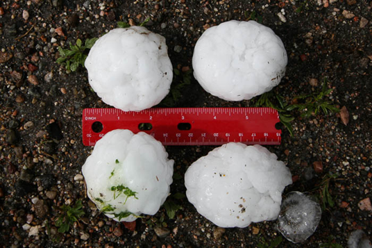
Figure 5 – Hail (Source: https://mping.nssl.noaa.gov/images/types/IMG_0114.jpg).
According to National Weather Service data stored in the Iowa Environmental Mesonet (IEM) database, the top 5 states for reported large hail of at least 1.0-inch in diameter (by number of days between January 1, 2012, and January 1, 2024) are:
- Texas (12-year average 197 days per year).
- Kansas (12-year average 131 days per year).
- Nebraska (12-year average 111 days per year).
- South Dakota (12-year average 74 days per year).
- Oklahoma (12-year average 73 days per year).
Tornadoes
Tornadoes are complex events that can occur primarily in both supercell thunderstorms as well as thunderstorm lines. Tornadoes form in ideal conditions when there are varying wind speeds at different altitudes within a storm event, which then get caught in a storm’s updraft. They are rated in strength by the Enhanced Fujita (EF) scale in the United States, and a variation of this same scale in Canada. The European Severe Storms Laboratory has proposed the newly developed International Fujita (IF) scale, which is used in several European nations.

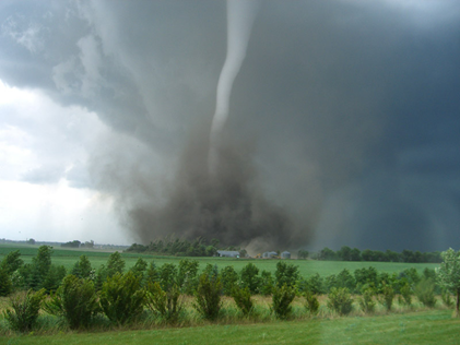
Figure 6 – A tornado (Source: https://www.nssl.noaa.gov/education/svrwx101/tornadoes/types/img/tornado-noaa.jpg).
Tornadoes can be brief and weak (often EF-0 or EF-Unknown), or long-lasting and powerful, such as an EF-3 through EF-5. Waterspouts are also tornadic, though they occur over water instead of land. If a waterspout makes landfall, it is then called a tornado.
Tornadoes can also form in tropical cyclones, though most are generally short lived and low on the EF scale, and typically occur on the right-hand side of the cyclone. Tornadoes in tropical cyclones are considered a separate meteorological event from the cyclone’s wind field (and warned accordingly), though they are typically a result of the parent tropical cyclone.
According to National Weather Service data stored in the Iowa Environmental Mesonet (IEM) database, the top 5 states for reported tornadoes (by number of days between January 1, 2012, and January 1, 2024) are:
- Texas (12-year average; 49 days per year).
- Kansas (12-year average; 26 days per year).
- Florida (12-year average; 25 days per year).
- Mississippi (12-year average; 23 days per year).
- Illinois (12-year average; 23 days per year).
What Is Not Considered a Severe Convective Storm by Meteorologists?
There are several types of meteorological phenomena that do not qualify as severe convective storms as defined by professional meteorologists. These include:
- Tropical cyclones (tropical storms, hurricanes, etc.). Generally, these are not considered severe convective storms. Some intricacies and caveats have been addressed in this article.
- Dust devils, sand whirls, and similar phenomena. These are rotating columns of air which can sometimes result in damage, injury, and death. However, they are not accompanied by a parent convective cloud.
- Gustnadoes (unless they result in severe wind gusts). Gustnadoes are generally shallow, short-lived vertical vortices within a thunderstorm gust front. Arguably, if the gust front and/or gustnado reaches severe-caliber speeds (50 knots or greater), this would qualify as a severe convective wind, but not a tornado.
- High winds associated with non-convective precipitation or no precipitation. Precipitation which occurs by non-convective means (such as during winter storms) can also be accompanied by high winds. However, because the event is non-convective in nature, the event is not considered a convective storm. Likewise, severe-caliber winds which occur by non-convective means with no precipitation (such as Chinook winds) are considered high wind events, not severe convective storms.
- Sleet (ice pellets). Sleet is a type of solid ice precipitation that can be mistaken for small hail. However, sleet is caused by the melting and refreezing of falling precipitation not generally associated with convective activity. Therefore, while in this scenario ice may be falling from the sky, it is not considered hail because it is created by atmospheric processes distinct from those which create hail. Regardless, sleet is generally less than 5 mm in diameter, far from the criteria for large hail.
- A thunderstorm which does not result in one-inch hail, 50-knot wind gusts or attributable damage, and/or a tornado is not considered (meteorologically, and within the US) a “severe” thunderstorm. In some cases, such a storm may be warned as a severe thunderstorm, but if no severe weather is noted or forensically identified, this warning may be considered a “false alarm.”
Additional Notes on Lightning and Severe Convective Storms
In the United States, severe convective storms are often considered synonymous with severe thunderstorms by operational meteorologists. For example, there is no “severe convective storm warning,” but rather a “severe thunderstorm warning.” The subtle difference between these two terminologies comes down to the presence of lightning. All thunderstorms are convective storms; therefore, all severe thunderstorms are severe convective storms, but not vice-versa.
In some cases, criteria for a severe thunderstorm may otherwise be met, except no lightning has occurred, such as a rain shower resulting in a 50-knot wind gust or short-lived landspout tornado. In these cases, meteorologists cannot consider this event a “severe thunderstorm” because a thunderstorm can only technically occur with the presence of lightning (hence, “thunder”).
For this reason, it is arguable that a storm itself may be considered a “severe convective storm” without technically being a “severe thunderstorm,” simply because of the lack of lightning. Lightning does not make the storm “severe,” but rather a “thunderstorm.” Therefore, lightning is not a severe element, but does change the meteorological nomenclature of the event.

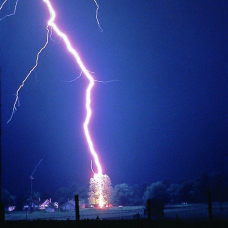
Figure 7: Lightning (Source: https://www.nssl.noaa.gov/education/svrwx101/lightning/).
A Note About Rainfall and Severe Convective Storms
Criteria in some nations (such as Canada) for severe thunderstorms also leave room for heavy rainfall as a qualifier. However, in the United States, no such qualifier for heavy rainfall within a convective storm exists. Therefore, in the US, a convective storm may result in significant flooding, but is not considered “severe” unless winds of 50 knots or greater, hail of 1.0-inch or greater in diameter, and/or a tornado occurs.
Ironically, by definition, no minimum precipitation amount is required for a convective storm to occur if other criteria are met. Therefore, it is possible for a severe convective storm to occur with no precipitation.

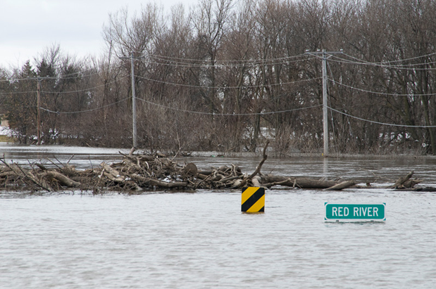
Figure 8: Flooding (Source: https://www.nssl.noaa.gov/education/svrwx101/floods/types/).
Underwriting and Policy Language Considerations
Meteorological terminology can be complex, intricate, and full of caveats. When defining terms within insurance policies, it is advisable to utilize common meteorological terminology and definitions as outlined by appropriate meteorological agencies, such as the United States’ National Weather Service (an agency of the National Oceanic and Atmospheric Administration) or the American Meteorological Society if writing in the US, and Environment Canada if writing in Canada.
By defining meteorological terms (such as severe convective storms) meteorologically, this allows forensic meteorologists to more simply qualify or disqualify events based on the meteorological event in question.
Conclusion
Severe convective storms are complex and diverse weather events, often unique in their own way. Therefore, forensic meteorologists are employed to analyze historical severe convective storm events related to insurance losses and other perils. Experienced forensic meteorologists understand the intricacies of a wide variety of weather events and can assist underwriters in meteorologically defining terms and considering the many caveats regarding weather often resulting in claimed losses. Furthermore, forensic meteorologists can also assist adjusters in properly characterizing a weather event claimed for a specific peril.
Acknowledgments
We would like to thank our colleague Daniel Schreiber for providing insight and expertise that greatly assisted this research.
Dan Schreiber is a Vice President in J.S. Held’s Forensic Meteorology service line. He is a Certified Consulting Meteorologist with years of experience in military, aviation, and severe weather operations. Mr. Schreiber has provided consulting and expert services for both plaintiff and defense law firms, as well as insurance adjusters, appraisers, umpires, and policyholders throughout North America. He has been consulted and/or retained as an expert in over 850 matters and has testified in both depositions and during trials in state and federal courts. He regularly plays an integral role in multi-million-dollar insurance disputes and injury/wrongful death lawsuits from coast to coast. Before joining J.S. Held, Dan was a highly successful meteorology business owner.
Dan can be reached at daniel.schreiber@jsheld.com or +1 830 453-0255.
References
[1] https://www.aon.com/en/insights/articles/rising-losses-from-severe-convection-storms-mostly-explained-by-exposure-growth [2] https://forecast.weather.gov/glossary.php?word=severe+thunderstorm [3] https://www.canada.ca/en/environment-climate-change/services/types-weather-forecasts-use/public/criteria-alerts.html [4] https://glossary.ametsoc.org/wiki/HailThis publication is for educational and general information purposes only. It may contain errors and is provided as is. It is not intended as specific advice, legal, or otherwise. Opinions and views are not necessarily those of J.S. Held or its affiliates and it should not be presumed that J.S. Held subscribes to any particular method, interpretation, or analysis merely because it appears in this publication. We disclaim any representation and/or warranty regarding the accuracy, timeliness, quality, or applicability of any of the contents. You should not act, or fail to act, in reliance on this publication and we disclaim all liability in respect to such actions or failure to act. We assume no responsibility for information contained in this publication and disclaim all liability and damages in respect to such information. This publication is not a substitute for competent legal advice. The content herein may be updated or otherwise modified without notice.